
| People |
| Michael |
| Meredith |
| Matthew |
| Jacob |
| Emily |
| Dave |
| Stevie |
| Lauren |
| Places |
| Cape Cod, MA 79-83 |
| New York, NY 83-88 |
| Mobile, AL 88-93 |
| Savannah, GA 93-98 |
| Atlanta, GA 96-01 |
| Savannah, GA 01-02 |
| Pensacola, FL 03-04 |
| Savannah, GA 04-09 |
| Mobile, AL 09-13 |
| Savannah, GA 13-16 |
| Washington, DC 16-20 |
| New Orleans, LA 20-22 |
| Savannah, GA 22-24 |
| Miami, FL 24- |
| _________________ |
| New Orleans, LA 98-00 |
| Londonderry, NH 00-02 |
| Cape Cod, MA 02-05 |
| New London, CT 05-08 |
| Merrimack, NH 08- |
| Links |
| Pools |
| Coding Challenges |
| Image of the Month |
| Flight School |
| Vegas Walk! |
Ok, this is a little Jet Log program I made that is very handy for those PESKY INAV problems, or for your XCountry stuff.
First, download/open this file JetLog.xls
Now i will attempt to walk you thru this thing.
It is preset to TH57 values but if you are good with Excel/Math then you can tinker with it and make it work for anything.
ONLY FILL IN BLOCKS THAT ARE COLORED (GREEN/BLUE). Unless you know what you are doing, don't touch the other blocks.
The first sheet is designed so you can put all the wind direction, speed, and air temp values that you are given in the problems. If you are just doing a XCountry flight, you only need to fill in the altitude at which you will be flying, and the average climb/descent altitudes. Or leave it blank and use no winds.
Temperature data needs to be filled in to compute True AirSpeed, so if you are doing the problems in the book, fill in what they give you, if you are doing a XCountry, just use the standard lapse rate numbers or what I already have in there.
Put the Wind Speed and Direction in for your Destination and Alternate in the Approach blocks. (A Approach = Alternate Approach)
Put in your Cruise fuel flow and the Variation (if Variation is East, use negative numbers), then move onto Sheet2
Here, all you have to fill in is the Cruise Altitude. If you are doing the problems, you will have to find this the long way (Excel doesn't know SemiCircular Cruising rules!!!).
Also fill in the appropriate Elevations and move on to Sheet3
OK, here comes the fun sheet.
Once again, only mess with colored blocks...
For the Departure to IAF section:
Fill in Course and Distances for each leg in the green boxes. (The program figures out Time to climb and breaks up the legs as needed into climbing and cruising legs so you don't have to worry bout that.)
If you have a holding leg, then leave the green box blank for that leg and put the time holding in the blue box instead.
Do the same for the Destination to Alternate section.
For the approach sections:
If you are arcing, put the start radial, end radial, DME, and a Y or a N if there is a Lead Radial depicted. Leave the Green blocks blank. NOTE: if arcing for more than 180 degrees, you have to split it up into two arc segments. IE if going clockwise from 270 to 180 radial, break it up into one arc of 270 to 90, then 90 to 180.
If you are not arcing (ie straight away/final) leave the blue blocks blank and fill in course and distance on the Green blocks.
If a procedure turn is required, put the time (7 minutes for procedure turn, 4 for holding turn, etc) in the blue P/T block
Do the same for the Alternate Approach section if required.
All done
The data you need for your Jet Logs will be on Sheet3 in the NON colored blocks (times, fuel, distances, etc)
Altitude and Airspeed data (along with Time To Climb (TTC)) is on Sheet2. The fuel data is also on Sheet2
You will probably have to get used to using the program and I would only use it to CHECK your work, cuz you are gonna need to know how to do Jet Logs without this thing.
NOW FOR AN EXAMPLE (what, you didn't think I would leave you hanging!):
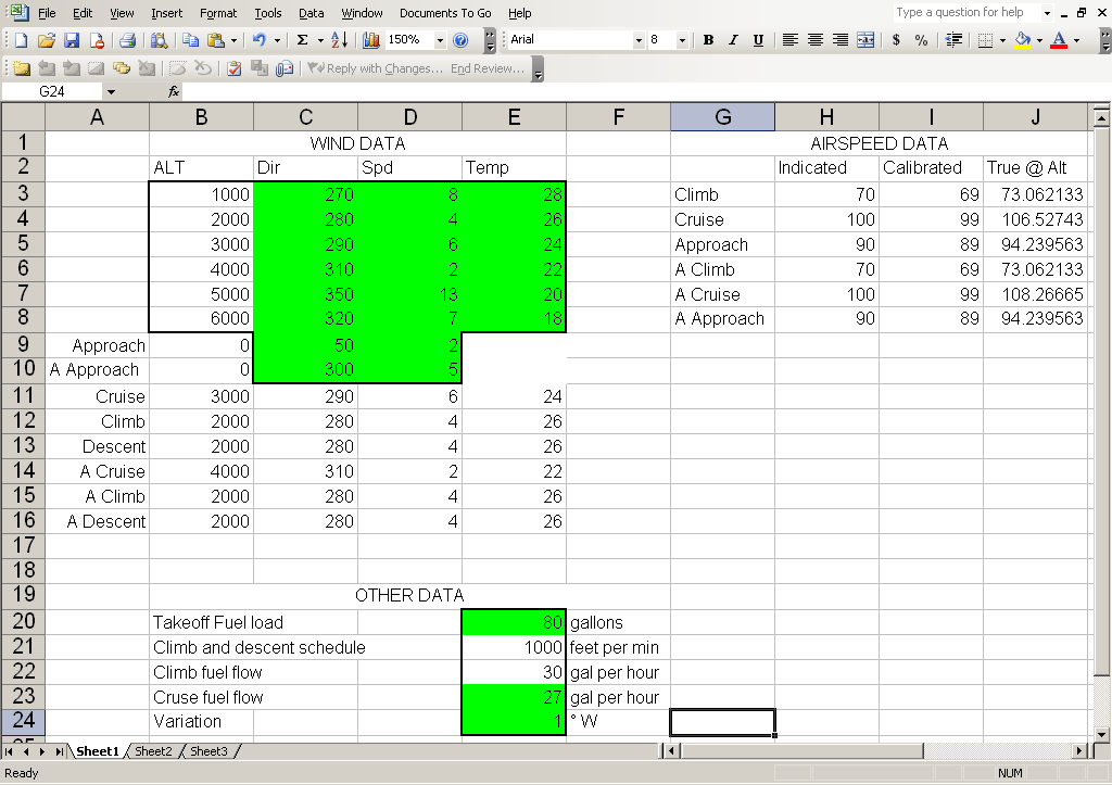
Notice on the above picture we have Sheet1
We've entered all our wind data for the altitudes and for our destination and alternate for our approaches.
We've also put in our Cruise Fuel Flow and our Variation.
On to Sheet2
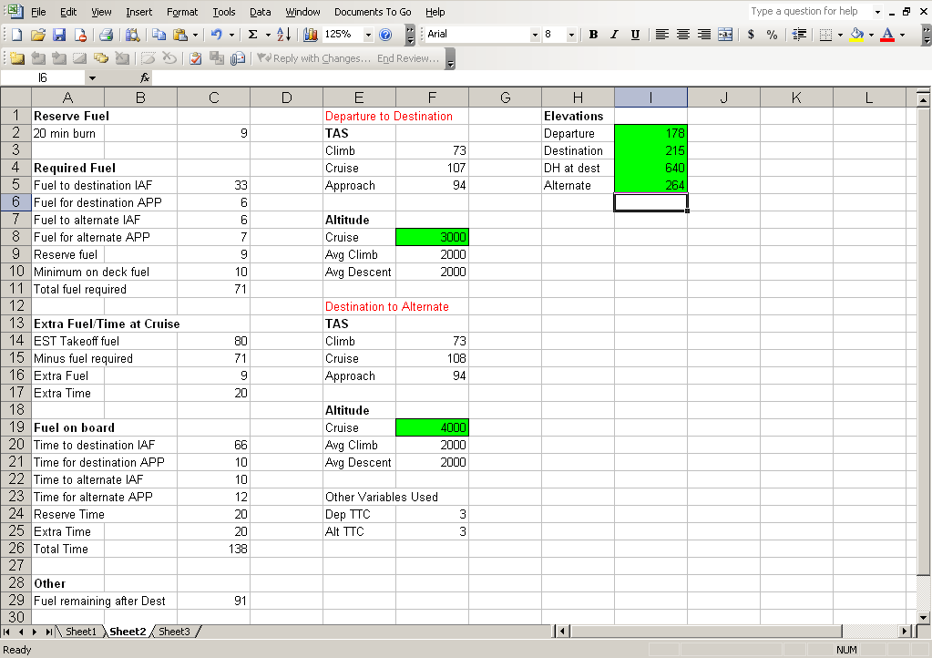
Ok, Sheet2... you'll notice we decided that 3000 was our best altitude for the trip, and 4000 turned out to be our best for the alternate.
The program will now use the wind and true airspeed data for those altitudes and for the average climb and descent altitudes.
We've also put in the elevations and the DH at our destination.
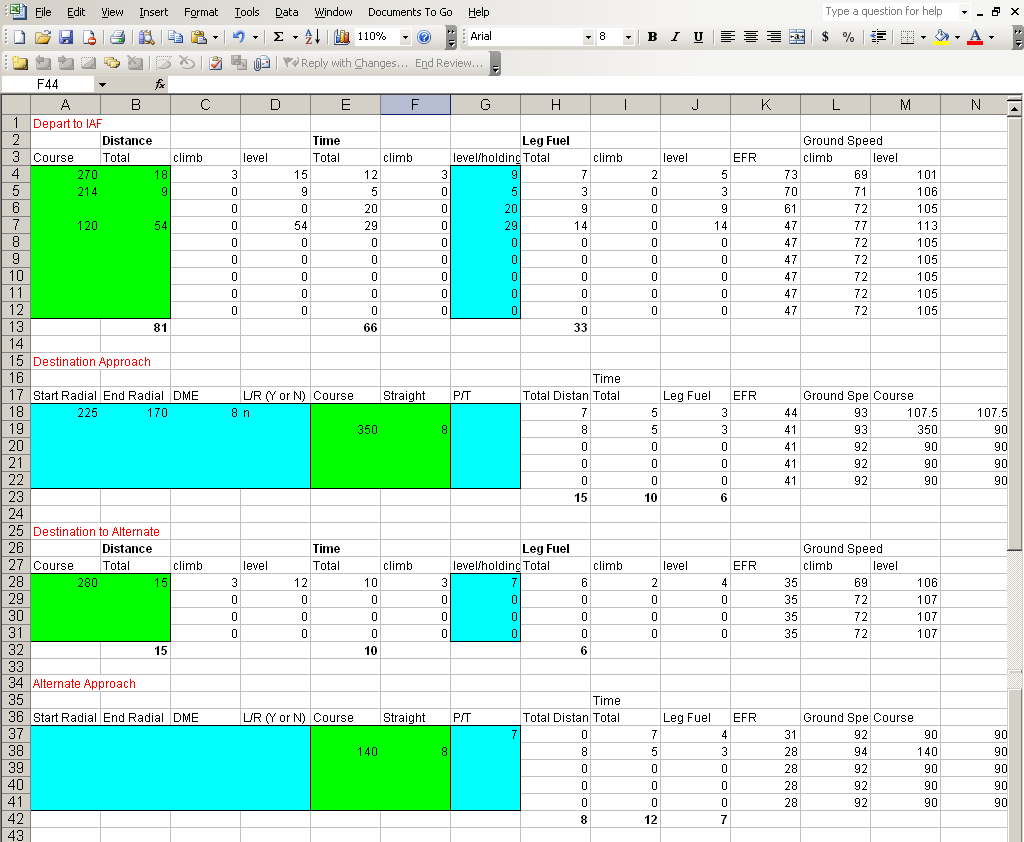
Ok, the fun sheet... Here's what we did.
The first leg of the trip is heading 270 for 18 miles. The program automatically figured out our TTC and therefore split up the amount of that leg that we would be climbing and the amount we would be level.
The second leg of the trip is heading 214 for 9 miles.
Then we decided to hold for 20 minutes. Notice that the green boxes for that leg are blank and we've manually put in 20 for the holding blue block.
The last leg (ie to our IAF) is heading 120 for 54 miles.
On to the Approach
This approach has an intial arcing segment starting at the 225 radial and ending at the 170 radial at 8 DME and does not have a LR depicted.
Then comes the straight away final segment heading 350 for 8 miles.
Alternate info is done just like the regular. We will be heading 280 for 15 miles to get to our Alternate IAF from our Missed Approach point (program uses DH for the climb out of the missed approach)
Then the approach at the alternate has a procedure turn that will take 7 minutes, so we put 7 in the blue box and leave all others blank
Then the straight away, 140 for 8 miles.
Now, we can fill in the blanks of our jet log, with the numbers produced on Sheet3. Total Distance, Time, Fuel, etc.
Then, we go back to sheet 2...
And on the left, you'll find the info to fill in the Fuel stuff.
Notice that all times are in minutes... ie 138 minutes is 2hrs and 18 minutes.
Also on this page, you can find the TAS and ALT. AND THAT'S IT!!! Piece of cake.
| Sorting Options | |
| 2016 | |
 Earrings!
12/26/2016 Earrings!
12/26/2016
|
|
 Rock Off
12/18/2016 Rock Off
12/18/2016
|
|
 Halloween 2016
10/31/2016 Halloween 2016
10/31/2016
|
|
 Dresser
10/16/2016 Dresser
10/16/2016
|
|
| 2012 | |
 Creating Cupcakes
12/22/2012 Creating Cupcakes
12/22/2012
|
|
 Kodiak Visit
10/4/2012 Kodiak Visit
10/4/2012
|
|
 San Francisco Visit
5/7/2012 San Francisco Visit
5/7/2012
|
|
 Custom iDock
1/28/2012 Custom iDock
1/28/2012
|
|
 New Van
1/5/2012 New Van
1/5/2012
|
|
| 2011 | |
 Emily's Video
10/28/2011 Emily's Video
10/28/2011
|
|
 Corpus Christi Visit
8/27/2011 Corpus Christi Visit
8/27/2011
|
|
 Port Angeles Visit
5/15/2011 Port Angeles Visit
5/15/2011
|
|
| Next Page |